Tuesday, May 26, 2015

Secretary Layne Announces Funding Options for I-66

Virginia Transportation Secretary Aubrey Layne announced today the initial results of the Commonwealth’s analysis of procurement options for the Transform I-66: Outside the Beltway project.  The analysis demonstrated that of the several available options for procuring the project, a publicly-financed design-build project may save taxpayers between $300 million and $600 million and provide for up to $500 million to be used for future transportation improvements in Northern Virginia.  Regardless of how the project moves forward, the McAuliffe Administration is committed to ensuring the transit capital and operating costs are supported by the project.
This analysis was undertaken at the request of Secretary Layne to ensure that all options for advancing major projects are considered to allow the Commonwealth Transportation Board to make informed decisions that provide the most benefits to the taxpayers.
“Smart transportation planning means gathering the best possible data to get the best deal for taxpayers, regardless of politics and ideology,” said Secretary Layne.  “With this analysis, the public and elected officials now know the options available to the Commonwealth and will have the opportunity to comment on the analysis.  Governor McAuliffe and his transportation team will continue to review these figures and prepare to make a recommendation on the future of this project this summer.”
Layne said the procurement options would either be a design-build contract managed by the Virginia Department of Transportation (VDOT) or a public-private partnership (P3) procurement. With both options, construction, operations and maintenance risks can be transferred to the private sector. Under the P3 procurement the financing risk and upside would also be transferred to the private sector, while under the design-build procurement the Commonwealth would retain that risk and any future excess revenues.
“As we work to get taxpayers the greatest value for every dollar they spend on this project, this analysis shows that there is merit to considering moving forward with a design-build contract,” said Layne. “Our administration would welcome a private partner on I-66, but they must propose the best deal for Virginia. Until we receive a better private proposal, these preliminary numbers indicate that a public finance option may be in the best interest of Virginia taxpayers.”
The cost to improve I-66 Outside the Beltway is approximately $2.1 billion.  The chart below demonstrates the potential differences between design-build procurement and a typical P3 procurement. According to the analysis, the design-build option could result in an additional $500 million to $1.1 billion in savings and tolling revenues, which could be reinvested in Virginia’s transportation system.
I-66 Outside the Beltway Preliminary Figures for Procurement Options:

Upfront Public Cost
Excess Revenues
Design-build/public financing
$400 million to $600 million
$200 million to $500 million
P3 financing
$900 million to $1 billion
$0
Projected savings of design-build/public financing option vs. P3 financing 
$300 million to $600 million
$200 million to $500 million

Layne has requested the Transportation Public-Private Partnership Advisory Committee, established by Governor McAuliffe’s P3 reform legislation (HB1886), hold a meeting to review and consider procurement options within the next 45 days.
Layne said, “I-66 Outside the Beltway is one of the most important projects being developed in Virginia. Given the significance of this project to taxpayers and to our economy, we owe it to Virginians to explore every available option for getting them the best value on every dollar they spend. This discussion should be driven by the numbers, not by empty ideology or outside interests. Governor McAuliffe and I are committed to working with local and state officials, the private sector and all stakeholders involved so that we can move forward together on a project for this corridor that eases congestion, stimulates economic growth and gets taxpayers the return on investment that they deserve. ”

Project Background: 
VDOT and the Virginia Department of Rail and Public Transportation are working on a project to transform 25 miles of I-66 from U.S. Route 15 in Haymarket to I-495/Capital Beltway into a multimodal corridor that moves traffic and people more efficiently. Under the proposed plan,     I-66 would be improved to provide:
  • Three regular lanes in each direction
  • Two express lanes in each direction
  • High-frequency bus service with predictable travel times
  • Enhanced commuter park and ride lots
  • Direct access between the express lanes and new or expanded commuter lots
The proposed express lanes would be dynamically-priced toll lanes designed to provide a reliable, faster trip. Drivers traveling with three or more occupants would be considered high occupancy vehicles, and could use the express lanes for free at any time.
Construction could begin in 2017 following public input and environmental approvals with project expected to open to traffic in 2021.

Wednesday, May 20, 2015

Start Your Summer with VDOT’s Travel Tools

RICHMOND, Va. – If summer travel is in your plans, the Virginia Department of Transportation (VDOT) is ready to help with mobile tools to keep you informed while you are on the go.
You can find real-time information about traffic, incidents and congestion on Virginia roads at 511Virginia.
Download the free mobile VDOT 511 app for Apple and Android devices to stay connected, or visitwww.511Virginia.org. Motorists also can reach 511Virginia by calling 511 from any phone in Virginia. Don’t drive distracted – please have your passengers make the call if you are driving or pull off the road to make the call yourself.
VDOT Lifts Lane Closures over Memorial Day Holiday
VDOT will suspend most highway work zones for several days over the Memorial Day holiday travel period to limit congestion and provide as many travel lanes as possible.
VDOT will lift lane closures on interstates and other major roads in Virginia from noon Friday, May 22, to noon Tuesday, May 26.
Travel Trend Map Shows When, Where to Avoid Peak Congestion
VDOT can help you avoid peak congestion times during the Memorial Day travel period. You can plan your arrival and departure times over the five-day travel period by using VDOT’s map of past travel trends for Virginia interstates.
VDOT has a map online that shows peak congestion periods on Virginia interstates during the three previous Memorial Day weekends (2012-2014).
The travel-trend map is available on the Virginia Roads website, located at www.virginiaroads.org (lower right on bottom of home page).
The map indicates varying amounts of interstate traffic by time of day, using red for heavy congestion, yellow for moderate congestion and green for little or no congestion. 
To use the map, slide the button along the date bar at the top of the map to update predicted traffic information at half-hour intervals between 7 a.m. and 10 p.m. for each day. You also can zoom and pan to specific areas of the state.
  • Based on the traffic data, periods of heavy congestion on the most recent Memorial Day weekends was most likely to occur between noon and 7 p.m. on Friday and Monday.
  • Historically, heavy congestion is present on Interstate 95 southbound and Interstate 64 eastbound from Saturday morning to Saturday afternoon.
While the map shows trends for delays during the most recent Memorial Day holidays, it cannot precisely predict congestion levels for this year’s five-day travel period.
NORTHERN VIRGINIA HIGH OCCUPANCY VEHICLE (HOV) SCHEDULE AND OTHER INFORMATION:
  • Friday, May 22: Normal HOV-3 restrictions are in effect. Interstate 395 and 95 Express Lanes reversible lanes will be southbound starting at noon.
  • Saturday, May 23: I-395 reversible lanes and 95 Express Lanes remain southbound until 2 p.m. and switch to northbound by 4 p.m.
  • Sunday, May 24: I-395 reversible lanes and 95 Express Lanes will be closed from 7 a.m. to approximately 11 a.m. for the Rolling Thunder motorcycle ride. When the lanes re-open, they will remain northbound for the remainder of the day.
  • Monday, May 25: HOV restrictions on Interstate 66 and I-395 are lifted. I-395 reversible lanes and 95 Express Lanes remain northbound all day.
More information on Northern Virginia HOV schedules can be found at http://www.virginiadot.org/travel/hov-novasched.asp.
For information on 95 Express Lanes and 495 Express Lanes, visit www.expresslanes.com. Drivers are reminded that they need an E-ZPass Flex (for HOV-3 to ride toll-free) or an E-ZPass to use the lanes at all times.
HAMPTON ROADS HOV SCHEDULE, TUNNELS AND OTHER INFORMATION:
  • Interstate 64/Interstate 264/Interstate 564 HOV diamond lanes – HOV restrictions will be lifted on all HOV diamond lanes on Monday, May 25.
  • I-64 reversible lanes − Lanes will operate on the regular schedule with no HOV restrictions on Monday, May 25.
I-64 Hampton Roads Bridge-Tunnel (HRBT) – Motorists traveling to Virginia Beach are encouraged to use the Interstate 664 Monitor-Merrimac Memorial Bridge-Tunnel (MMMBT) as an alternative to the HRBT. To Virginia Beach, take I-664 south to the MMMBT. Then take the Portsmouth/Norfolk exit (exit 15A) to Interstate 264 east to Virginia Beach.
  • Highway Advisory Radio (HAR) – Tune to 1680 AM to stay informed on Hampton Roads traffic, travel conditions and construction information.
WORK ZONES AND OTHER TRAFFIC ALERTS
While VDOT will lift most lane closures during the Memorial Day holiday period, motorists may encounter permanent work zones or travel delays in the following locations:
Amherst County
Route 501/Route 130 – Traffic controls and flaggers in use during construction.
Ashland
Route 54 – Travel on bridge over I-95 remains limited to one lane each direction for bridge replacement.
Augusta County
Route 250 (Hankey Mountain Highway) – Traffic restricted to one lane for bridge replacement at White Oak Draft, about 11 miles west of Staunton. Temporary traffic signal in operation. Traffic also restricted to one lane for bridge replacement at Calfpasture River, about 15 miles west of Staunton. Temporary traffic signal in operation.
Botetourt County
Interstate 81:
  • Replacing Route 608 bridge over interstate near mile marker 170. Work under bridge requires lane closures bothdirections, Sundays-Thursdays, 10 p.m.-6 a.m., at various times. Detour signs directing traffic on Route 608 (Indian Rock Road)
  • Daytime lane closures may be in place on Route 676 over I-81 for bridge repairs. Shoulder paving to be done 10 p.m.-6 a.m., Sunday−Thursday, with travel lane on I-81 closed.
Bristol
Interstate 81 – Improving interchange at exit 7. Expect delays. Motorists can use exits 5 and 10 to avoid work zone to access area roads and businesses.
Carroll County
Route 58 – Improving road between Laurel Fork and Meadows of Dan. Periodic lane closures, 7 a.m.-5:30 p.m., with flagging crews directing traffic. Watch for changes in traffic pattern and trucks entering, exiting highway.
Charles City County
Route 5 – Replacing bridge over Herring Creek. Traffic directed by temporary signal.
Dinwiddie County
Interstate 85 – Left southbound lane closed at mile marker 58 for paving through the weekend.
Essex County
Route 17 − Improving drainage, from just south of Airport Road near June Parker Marina to just north of Marsh Street. Traffic reduced to one lane both directions.
Henry County
Route 58 − Weather permitting, starting May 18, westbound traffic will be detoured to eastbound Route 58. One traffic lane will remain open each direction. Twelve-foot lane-width restriction. Speed limit 45 mph in work zone.
Madison County
Route 231 – Replacing bridge over Mulatto Run. Traffic restricted to one lane controlled by temporary signals.
Montgomery County
Route 8 – Single-lane closure on Route 8 (Riner Road) near Route 699 (Fairview Church Road) for work related  to commercial development. 
Prince Edward County
Route 15 – One lane closed for structure work over railroad near Charlotte County line. Temporary signal in place.
Richmond
Route 360 − Travel remains limited to two lanes on Mechanicsville Turnpike over I-64 for bridge deck replacement, with one travel lane each direction.
Rockbridge County
Interstate 64: Eastbound traffic will detour across the median to the westbound side of interstate between mile markers 53.3 and 55.3. Traffic both directions will use westbound Maury River bridge during rehabilitation of eastbound bridge. Speed limit 55 mph.
Wythe County
Interstate 77/Interstate 81 overlap – High traffic volumes could slow or stop vehicles through this eight-mile stretch. Be alert to delays on northbound I-77 at the I-81 merge.
Motorist Safety Tips
VDOT encourages all motorists to do their part to prevent highway crashes by following these safety tips while driving:
  • Buckle up
  • Avoid distractions
  • Share the road
  • Drive drug- and alcohol-free
  • Obey speed limits
Additional Travel Tools
Lane closures and incident reports available on 511 also are communicated through VDOT’s Twitter accounts, targeted for different regions of Virginia and specific interstate corridors, such as Interstate 95 or Interstate 81.
Visit http://www.virginiadot.org/newsroom/vdot_twitter_feeds.asp for a list of VDOT’s Twitter accounts and information on how to subscribe.
Follow your region (511 traffic feeds):
Follow your district:
VDOT’s Customer Service Center
To report a road hazard or get answers to your transportation questions, call VDOT’s Customer Service Center at800-FOR-ROAD (800-367-7623) around the clock.
For information about major long-term construction projects on Virginia’s interstates and primary roads, visithttp://www.virginiadot.org/travel/major_road_construction_projects.asp for VDOT’s interactive “Road Construction Ahead” map.
E-ZPass
Virginia belongs to the E-ZPass electronic toll-collection network. E-ZPass customers can use their transponders at toll facilities in Virginia and 14 other states. For more information on E-ZPass, visit www.ezpassva.com.

Tuesday, May 19, 2015

Virginia is Friendliest Bicycling State in the South

RICHMOND, Va. – The League of American Bicyclists released its 2015 Bicycle Friendly States (BFS) rankingyesterday and Virginia placed 13th nationally with a regional ranking of 1st in the south.
Virginia has designated 838 miles of U.S. Interstate Bicycle Routes and was the first to do so in 1982. The Virginia Department of Transportation (VDOT) works to incorporate bicycling facilities into new projects and expands paved shoulders on existing roadways where possible.
“We’re pleased that Virginia’s national ranking improved from 18th in 2014 to 13th this year,” said VDOT Commissioner Charlie Kilpatrick. “VDOT has taken the time to listen to our partners in bicycling communities across the commonwealth. We continue to look for opportunities to improve bicycling safety and accessibility throughout Virginia.”
The BFS ranking is based on a number of key indicators, including infrastructure and funding that provide bicycle facilities; education and encouragement programs that promote bicycling; and passage and enforcement of bicycle-friendly laws that make it safe and easy for people of all ages to ride.
Another factor cited in Virginia’s ranking included recognition of the 2014 General Assembly adoption of the three-foot passing law. In addition, several planning projects contributed to Virginia’s higher ranking including a realignment of U.S. Bicycle Route 1 in Northern Virginia and the upcoming completion of the 52 mile Virginia Capital Trail which will boost business and tourism.
For more information on the League of American Bicyclists Bike Friendly State Rankings, visit www.bikeleague.org.
To learn more about VDOT’s Bicycle and Pedestrian Program visit http://www.virginiadot.org/programs/bk-default.asp.


Thursday, May 14, 2015

10 Steps To Take 100,000 Cars Off DC's Roads

Want to reduce the number of cars driving around DC each day? The fastest way to do it may be a relatively cheap and non-controversial set of marketing and incentive programs, collectively called Transportation Demand Management (TDM).

Image from Mobility Lab.
TDM isn't infrastructure. Rather, it's a set of dedicated information, encouragement, and incentives that help people use existing infrastructure more easily and efficiently.
And boy, does it work.
For only about $10 million annually, Arlington's robust TDM program converts about 42,000 car trips to alternative modes on Arlington's roads every day. If DC had a similarly robust program, it might be even more successful. 100,000 cars a day would be a totally achievable goal.
DC already has a nascent TDM program called goDCgo. Right now goDCgo is too small to make much difference, but moveDC calls for a big expansion "based upon the model of Arlington." Here are ten steps to actually get there:
Read the full list at Greater Greater Washington.

Wednesday, May 13, 2015

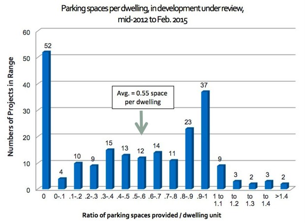
Seattle to Buildings: Give Tenants Transit Passes, Not Parking Spots

After decades of telling residential developers to build a minimum amount of parking for tenants, smart cities are now looking for ways to discourage the creation of unnecessary spaces. That’s because while some people enjoy the amenity of a personal spot, residential parking also makes housing lessaffordable (by jacking up rents to defray the cost of building a garage or a lot) and makes traffic more awful (by encouraging commuters to drive to work). It's a small win for a large loss.
Seattle is among the U.S. metros working hard to change the situation. Years ago it eliminated a rule requiring developers to build parking for new buildings located in downtown or transit-friendly areas. That policy has produced mixed returns; some housing developments provide no parking for tenants, while some still build nearly a spot per person, leading to just over half a space per unit, on average:
Read the rest of the article at CityLab.

Tuesday, May 12, 2015

VDOT, DRPT Seek Your Input on I-66 in Northern Virginia

 FAIRFAX - At four upcoming public hearings, the Virginia Department of Transportation (VDOT) and Department of Rail and Public Transportation (DRPT) will ask for input on the Tier 2 Environmental Assessment for improvements on Interstate 66 outside the Capital Beltway, as well as revised design concepts that have reduced potential residential relocations by half. This information will be presented at hearings scheduled on May 27 and 28, and June 2 and 3. The public is invited to review and comment on:
  • The Tier 2 Environmental Assessment, which evaluates potential effects the proposed improvements would have on air quality, noise, neighborhoods, parks, recreation areas, historic properties, threatened and endangered species habitats, wetlands and streams.
  • Updated design concepts, which reflect revisions where possible on roadway elements andstormwater management ponds to reduce impacts and preserve nearby homes.
This information will be available to the public beginning on May 12 at www.Transform66.org or at VDOT's Northern Virginia District Office in Fairfax. The public comment period for this stage of the project extends until June 18.
"The upcoming public hearings and opportunities for input are critical to our ongoing efforts to engage the public and determine the most effective and least impactful solutions to improve I-66 outside the Beltway," said Virginia Secretary of Transportation Aubrey Layne. "Since the initial roll-out of the project's concept plans in January and February, and after hearing public input at more than 30 community meetings, VDOT has continued to focus on minimizing the project's footprint, significantly reducing the number of potential residential relocations by more than half. This effort to reduce impacts will continue as the environmental and design process moves forward."
Preliminary design concepts presented at public information meetings earlier this year showed the potential for 32 to 35 residential relocations, depending on the selected designs. Design revisions now show the number of possible residential relocations to bebetween 11 and 18. All 12 of the homes that were impacted by new stormwater management ponds are preserved in the updated designs, as well as homes close to the proposed flyover ramp near the Dunn Loring area, east of Nutley Street. 
Following the upcoming environmental public hearings, VDOT and DRPT will continue design work with a focus on further minimizing impacts and making the best use of infrastructure that is already in place. Final right of way impacts will be presented to the public at design public hearings in mid-2016. Construction of the project is slated to begin in 2017. 
The I-66 Outside the Beltway Project proposes improvements from Route 15 in Haymarket to I-495, and involves two express or high occupancy toll (HOT) and three regular lanes in each direction, along with high-frequency bus service in the express lanes with predictable travel times and direct access between the express lanes and new or expanded commuter lots. For more information, go to www.transform66.org.

Thursday, May 7, 2015

Columbia Pike residents are impatient for new transit plan

Columbia Pike residents and businesspeople have been waiting since November to hear what’s next after the long-planned Arlington streetcar project was abruptly canceled. What’s next, they learned Thursday night, is more waiting.
A forum on the Pike’s future drew more than 100 people but few answers about how to handle the need for mass transit along Virginia’s busiest bus corridor. The audience, full of people who had worked for years on the streetcar plans, had pointed questions for the panelists, who included County Board member John Vihstadt (I), whose election was the tipping point in the $550 million project’s demise.
Moderator Del. Alfonso H. Lopez (D-Arlington), who represents the area in the Virginia House of Delegates, noted that county leaders had promised a new plan “within weeks, then months and now it’s headed into next year. . . . Promises were made over a 10, 15, 20 year period and our political leaders didn’t stick by those promises in some cases.”
Read the rest of the story at the Washington Post.

Wednesday, May 6, 2015

End of the Car Age: How Cities Are Outgrowing the Automobile

Gilles Vesco calls it the “new mobility”. It’s a vision of cities in which residents no longer rely on their cars but on public transport, shared cars and bikes and, above all, on real-time data on their smartphones. He anticipates a revolution which will transform not just transport but the cities themselves. “The goal is to rebalance the public space and create a city for people,” he says. “There will be less pollution, less noise, less stress; it will be a more walkable city.” 

 Vesco, the politician responsible for sustainable transport in Lyon, played a leading role in introducing the city’s Vélo’v bike-sharing scheme a decade ago. It has since been replicated in cities all over the world. Now, though, he is convinced that digital technology has changed the rules of the game, and will make possible the move away from cars that was unimaginable when Vélo’v launched in May 2005. “Digital information is the fuel of mobility,” he says. “Some transport sociologists say that information about mobility is 50% of mobility. The car will become an accessory to the smartphone.” 

 Vesco is nothing if not an evangelist. “Sharing is the new paradigm of urban mobility. Tomorrow, you will judge a city according to what it is adding to sharing. The more that we have people sharing transportation modes, public space, information and new services, the more attractive the city will be.” 

 The Vélo’v scheme is being extended, car clubs that use electric vehicles are being encouraged, and what Vesco calls a “collaborative platform” has been built to encourage ride-sharing by matching drivers with people seeking lifts. There is, he says, no longer any need for residents of Lyon to own a car. And he practises what he preaches – he doesn’t own one himself.

Read the rest of the story at The Guardian.

Tuesday, May 5, 2015

The Hardest-Working Bike in Washington, D.C

To the naked eye, W20167 is just another apple-red Capital Bikeshare bike, but Dupont Circle resident Mike Azar, 29, knows better. By crunching publicly released data by Capital Bikeshare, Azar identified W20167 as the hardest working bicycle in the Capital Bikeshare fleet, logging 483 hours during 1,567 rides last year.
“That’s a lot of rides — about 130 per month, compared to the average bike’s 86” says Azar, an instructor at the Johns Hopkins School of Advanced International Studies, who posted his findings on his blog.
The data on W20167 show that the James Brown of bikes has spent a lot of time circulating between some of Bikeshare’s most popular stations, including Union Station, Dupont Circle, and the Lincoln and Jefferson Memorials. It also went on some epic rides, including one that was nearly 12 hours long.
Read the rest of the story at the Washington Post.

Monday, May 4, 2015

Comment on Draft P3 Public Engagement Guidelines


PUBLIC FEEDBACK SOUGHT ON DRAFT P3 PUBLIC ENGAGEMENT GUIDELINES
RICHMOND – The Commonwealth is seeking public feedback to improve the state’s process to deliver transportation projects under the Public-Private Transportation Act, as part of Virginia’s P3 program. The Virginia Office of Public Private Partnerships (VAP3) is leading the state’s efforts to create a process that is transparent, competitive, and accountable to taxpayers in every aspect of the P3 projects being developed.
To date, the VAP3 has revised and enhanced the 2014 PPTA Implementation Manual and Guidelines.  A suite of companion “Guidelines” follow the enhancement of the PPTA Implementation Manual and Guidelines to provide more detailed information on the areas such as Risk Management, Public Engagement, and Value-for-Money.
Consistent with Governor Terry McAuliffe’s objectives of enhancing transparency and accountability to taxpayers, the VAP3 has established both programmatic and project specific public engagement processes. These processes provide for more meaningful opportunities for public engagement and awareness related to Virginia’s P3 program and projects.
The VAP3 is seeking feedback and comments from individuals, private companies, industry groups and public officials regarding the newly created draft P3 Public Engagement Guidelines, released today.
The draft P3 Public Engagement Guidelines can be accessed by visiting the VAP3 website (www.p3virginia.org), selecting “Resources,” then selecting “Manuals, Guidelines, Publications and Resources” from the dropdown menu.  To submit comments, go to Request for Comments on draft P3 Public Engagement Guidelines.
Comments are due by June 1, 2015. 
The VAP3 will review all comments and take them into consideration while finalizing the P3 Public Engagement Guidelines. The Commonwealth Transportation Board will be briefed on the P3 Public Engagement Guidelines and the final version will be posted on the VAP3 website.