Wednesday, August 31, 2016

Bike Share: Bridging The Gap

I’ve been an enormous fan of rail and bus travel for as long as I can remember.  For a modest price, I can travel to cities in New York State while I relax, read, or get work done on the way.  Living in Rochester New York, which has an Amtrak and a Greyhound Station within a few hundred feet of each other, it’s relatively easy for me to break the shackles of traveling across the Empire State behind the wheel of a car.

The problem for me and many who enjoy traveling this way is, simply, what do we do when we arrive at our destination?  Most train and bus stations are located in downtown areas, making it easy for travelers toaccess the best of what cities have to offer. However, many city attractions are still several miles away from mass transit, far enough to discourage the average day trip adventurer.  Cabs in small Upstate New York cities are expensive, ride sharing like Uber and Lyft are illegal in New York State outside of New York City due to insurance regulations, and local bus systems can be confusing and inconsistent.
So how do we bridge the physical gap between regional mass transit options and city destinations?  The answer may rest in the growing movement of bike share.

Read the rest of the story here.

Tuesday, August 30, 2016

Engineers To U.S. DOT: Transportation Is About More Than Moving Cars

A trade group representing the transportation engineering profession thinks it’s high time for American policy makers to stop focusing so much on moving single-occupancy vehicles.
Should roads like this be considered a "success?" ITE doesn't think so. Photo: Smart Growth America
Should roads like this be considered a success? ITE doesn’t think so. Photo:Smart Growth America
U.S. DOT is currently deciding how it will assess the performance of state DOTs. Will it continue business as usual and equate success with moving huge numbers of cars? That’s what state transportation officials want, but just abouteveryone else disagrees — including professional transportation engineers.
In its comments to the Federal Highway Administration about how to measure performance, the Institute of Transportation Engineers — a trade group representing 13,000 professionals — said that, in short, the system should not focus so heavily on cars [PDF].
Here’s a key excerpt:
Throughout the current proposed rulemaking on NHS performance, traffic congestion, freight mobility, and air quality, an underlying theme is apparent: these measures speak largely to the experience of those in single occupancy vehicles (SOVs). While such a focus is understandable in the short-term, owing largely to the current availability of data from the NPMRDS and other national sources, ITE and its membership feel that FHWA should move quickly within the framework of the existing performance management legislation to begin developing performance measures that cater to multimodal transportation systems.
The first step in this process is instituting a program to develop standards and procedures for data collection within this alternative modes of travel, an effort which ITE feels should be undertaken by FHWA and its USDOT partner agencies concurrent to the final performance management rulemaking under consideration. Once this multimodal framework is established, FHWA can work to develop a more comprehensive and holistic set of performance measures that accommodate multiple modes of transportation, while achieving secondary effects of improved public health, community livability, and economic development.
Read the rest of the story here

Monday, August 29, 2016

What Makes A City Walkable Or Unwalkable?

Walking is the oldest and simplest form of human transportation. Nowadays, walking a few blocks or crossing a street seems inconvenience. Walkability is a new term to describe how friendly a city or a neighborhood is to pedestrian activity. According to the Walkable and Livable Communities Institute, walakble communities are defined as: “they consider persons, not their automobiles, at the center of the design scale. When we design communities around the human foot, we create places that are socially, environmentally and economically vibrant”.
Walkability is the key to an urban area’s efficient ground transportation. Walking remains the cheapest form of transport for all people. Thus, the construction of a walkable city provides the most affordable and equitable transportation system, where any community can plan, design, build and maintain. Walkable cities return urban environments to scale, pattern and mix for sustainability of resources (both natural and economic). They lead to addressing many social and economic problems through social interaction, physical fitness, diminishing crime and increasing wellness. Walkable cities are livable built environments which lead to whole happy and healthy lives for the people who live in them. They keep jobs and attract young adults, families and children (www.walkable.org).
Read the rest of the story here.

Thursday, August 25, 2016

Self Driving Cars And Cities

Ten years ago I found myself standing outside the Automotive Hall of Fame in Dearborn, Michigan. I looked out over acres of glinting windshields in a packed parking lot. I’d reached this spot by driving from Ann Arbor on the I-94, where the highway sometimes reaches 12 lanes across, in a little over an hour. Public transit would have taken me three and a half hours. What would Henry Ford think, one hundred years after the birth of the car? Pride or horror
It took 50 years to transition from the horse to the car. Surely few could have imagined the impact the car would have as it tore through cities, countries, and economies worldwide. Today, average Americans spend almost two of their eight hours at work paying off their car, which they need to get to that job. Last year in the US, more than 38,000 people died and 4.4 million were seriously injured due to motorized transport. Farther afield, in Singapore, 12 percent of the island nation’s scarce land is devoted to car infrastructure. In Delhi, 2.2 million children have irreversible lung damage because of poor air quality.
Incredibly, we might actually get a chance at a do-over — of our cities, our fossil fuel dependence, and the social contract with labor — thanks to the impending advent of autonomous cars. Yes, their arrival is inevitable, but how they will impact us is yet to be determined.
Read the rest of the story here.

Wednesday, August 24, 2016

Guerrilla Bike Lanes Show Cities How Easy It Is To Make Streets Safer

One night in June, a driver sped through the wrong lane of traffic in Golden Gate Park in San Francisco—trying to pass another car—and killed a cyclist riding legally in the other direction. A couple of hours later, another driver in the city's SOMA neighborhood sped through a red light and killed a 26-year-old woman on a bike.
The next day, the director of transportation at the SFMTA told a reporter that "the best bike infrastructure in the world would not have prevented these collisions." Bike and pedestrian advocates disagree, and since the city hasn't done much to help, they're taking action themselves—temporarily redesigning local bike lanes themselves.
Read the rest of the story here.

Tuesday, August 23, 2016

BTS Releases Smartphone App for Pocket Guide to Transportation

The U.S. Department of Transportation’s Bureau of Transportation Statistics (BTS) has introduced its most innovative product – a smartphone app for the Pocket Guide to Transportation 2016. The Pocket Guide is a popular, quick reference guide to significant transportation statistics. 

The new app allows users to take all the informative graphics and tables from the guide with them without having to carry a copy of the Pocket Guide. All of the features of the annual Pocket Guide will be available from both the iTunes App Store for iPhone and iPad and the Google Play store for Android devices. All seven sections – Infrastructure, Moving People, Moving Goods, Performance, Economy, Safety and Environment – plus a new Major Trends section can be found on the app. 

To link to the iTunes and Google Play download sites, go to the BTS Pocket Guide to Transportation page. 

For inquiries other than placing orders contact Dave Smallen: 202-366-5568.

Monday, August 22, 2016

Bicycle Safety: The Road To Mutual Respect Between Cyclists And Motorists

Mark Atkins spends a lot of the time in the company of avid cyclists. As president of the North Florida Bicycle Club, he’s one of them.
They love being on the road, but they encounter their share of frustrations and fears, many of which are caused by motorists.
The list, Atkins said, based on his on experience and conversations with other cyclists, includes impatient drivers, distracted drivers and drivers who don’t give bicyclists sufficient space when passing them.
“I think there are many drivers who just don’t know how they’re supposed to behave around cyclists,” he said, “and who don’t know or appreciate that cyclists have a right to be on the road.”
But there is a flip side, Atkins admitted.
Read the rest of the story here.

Friday, August 19, 2016

Let a Thousand Ride Shares Bloom

We’re in the midst of an unfolding revolution in transportation technology, thanks to the advent of transportation network companies. By harnessing cheap and ubiquitous communication technology, Uber and other firms organizing what’s being called “ride-hailing” services have not only disrupted the taxi business, but are starting to change the way we think about transportation. While we think of disruption here as being primarily driven by new technology, the kinds of institutional arrangements—laws and regulations—that govern transportation will profoundly determine what gains are realized, and who wins or loses.

Right now, Uber has an estimated market value (judging by what recent investors have paid for their stake in the company) of nearly $70 billion. That’s a whopping number, larger in fact than say, carmakers such as Ford and GM. It’s an especially high valuation for a company that has neither turned a profit nor gone public, thus subjecting its financial results to more outside scrutiny. Uber’s generous valuation has to be based on the expectation that it’s going to be a very, very large and profitable firm, and that it will be as dominant in its market as other famous tech firms—such as Microsoft or Google—have been.

The importance of competition

For a moment, it’s worth thinking about the critical role of competition in shaping technology adoption and maximizing consumer value. Take the rapidly changing cell phone industry, which has increasingly replaced the old wire-line telephony of the pre-digital era. Back in the day, phone service—especiallylocal phone service—was a regulated monopoly. It barely changed for decades. The two biggest innovations were princess phones (don’t ask) and touch-tone dialing.

Read the rest of the story here.

Thursday, August 18, 2016

Study: Even Drivers Prefer Protected Bike Lanes

When it comes to allocating street space, it is often taken for granted that anything that benefits people on bikes harms people who drive. Such assumptions are contradicted by data showing that cycling infrastructure makes streets safer for all users, and don’t mesh with a new study on motorist preferences.
In the latest issue of “Transportation Research,” a survey of Bay Area drivers and cyclists, conducted by Rebecca Sanders of Toole Design Group, found support for protected bikeways across the board.
Network blogger Tim Kovach reports:
According to Sanders, hers is the first study to ask drivers about their preferences for roadway design when it comes to sharing the road with cyclists.
She and her colleagues sent out a survey to 1,177 people in the San Francisco Bay Area in July 2011, asking respondents to rate their level of comfort on a series of different commercial road designs when driving near cyclists or cycling near near cars going 25-30 miles per hour. The various road designs included no bike infrastructure, sharrows, on-road bike lanes, and separated bike lanes. Sanders then followed up by holding a series of focus groups with respondents to get additional information.
Read the rest of the story here

Wednesday, August 17, 2016

Top 5: The Best Safety Gear for Urban Cyclists

There’s a seemingly endless number of products on the market designed to keep urban bicyclists safe. LED-enabled smart helmets, fluorescent jackets with reflective arrows, backpacks that signal turns, rear lights which project bicycles onto the ground behind you, and the list goes on. With such a dizzying array of choices to keep yourself safe on the roads, it can be difficult to decide which types of equipment are the most effective, and where we should be investing our money.
In an effort to clear things up a bit, we’ve rounded up a list of our top 5 cycling safety innovations that no urban cyclist should be without. While I guess it’s not really “gear” so much as “infrastructure,” is now really the right time to nitpick about diction?

1. Buffers

protected bike lanes
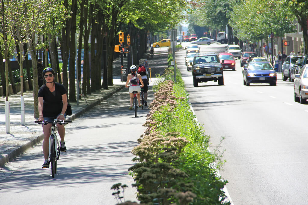
A planter-box buffer protects Vancouver’s Hornby Street bike lane from vehicle traffic. Photo by Paul Krueger.
Buffers top the list for urban cycling safety gear because of their proven effectiveness at keeping people on bikes from getting smushed by people driving cars. While painted-on bike lanes are certainly a step in the right direction for cycling safety, they’re only as effective as motorists’ willingness to avoid driving or parking in them. Buffers are the game changer – by physically separating vehicle traffic from bicycle traffic, they can basically eliminate conflicts between the two modes. We decided to give the top spot to buffers rather than the infrastructure they’re commonly associated with (protected bike lanes), because they can also be employed in the less common but equally important protected intersection, and do their life-saving thing all the way through the road network.
While buffers are most commonly seen in the form of bollards or simple concrete barriers, many cities are going the extra mile and building planter-box buffers such as the one above. Both stylish and practical!

Read the rest of the list here!

Tuesday, August 16, 2016

Governor Announces Groundbreaking for I-66 Inside-the-Beltway Improvements

Governor Terry McAuliffe today announced that work will begin this summer on the first major improvements to Interstate 66 inside the Beltway in 15 years. The project is part of a comprehensive initiative to transform the I-66 corridor, giving commuters and other travelers a variety of fast and reliable choices for getting to and from work.
“Since the beginning of our administration, we made it our top transportation priority to improve Virginia’s infrastructure and unclog the bottlenecks on our most congested highways,” said Governor McAuliffe, speaking at the groundbreaking ceremony. “This project is a big step forward in our work to transform one of the most important corridors in Northern Virginia, and it will ensure that drivers have faster, safer and more reliable commutes every day. This initiative, coupled with Virginia’s new SMARTSCALE transportation prioritization process, will unlock Northern Virginia from the traffic congestion that was strangling this region’s economic potential.”
The Virginia Department of Transportation (VDOT) project will give commuters more flexibility from the Capital Beltway to the Lee Highway exit in Rosslyn. The initial project includes the installation of tolling equipment along this corridor and signage on local streets approaching the highway. The new I-66 inside the Beltway will be the nation’s first roadway with dynamic tolling on all lanes during peak-period traffic, keeping traffic moving at highway speeds by adjusting toll prices based on traffic volume.
“This project also moves us one step closer to giving travelers an express lanes network across more than 90 miles in Northern Virginia,” said Virginia Secretary of Transportation Aubrey Layne. “With this project, we’re providing better ways to get around and helping to reduce the congestion that now burdens so many of us.”
Toll revenues will fund multimodal improvements, giving commuters expanded options for travel. To jumpstart the process, the Commonwealth Transportation Board recently approved a nearly $10 million program to fund a series of multimodal projects identified by the Northern Virginia Transportation Commission. 
Contracts totaling $60 million were awarded to Fort Myer Construction for tolling infrastructure construction and to TransCore for tolling equipment installation. The project includes eight overhead electronic toll collection gantries on I-66 and approximately 125 signs along I-66 and local roads approaching the highway. The work will require periodic lane closures on local roads approaching I-66 interchanges, ramp closures and night-time lane closures along I-66 itself. Brief, occasional total closures of I-66 will occur during overnight construction to install the overhead gantries. Construction will conclude next year.
In addition to these improvements, a four-mile segment of eastbound I-66 from the Dulles Connector Road to Fairfax Drive will be widened to provide further congestion relief.  
For more information, please visit www.Transform66.org.

Monday, August 15, 2016

Localities, Regional Entities Asked to Submit Projects Under Smart Scale

RICHMOND – Localities and regional entities such as metropolitan planning organizations and transit agencies can submit project applications under the SMART SCALE program (formerly House Bill 2) from Aug. 1 to Sept. 30 this year. This marks the second round of applications as projects will compete for funding available in the outer years of the six-year program.
SMART SCALE stands for System for the Management and Allocation of Resources for Transportation, and the key factors used in evaluating a project’s merits: improvements to safety, congestion reduction, accessibility, land use, economic development and the environment.
Localities and regional entities are encouraged to get their applications in this round as the next round will not be held until 2018 and applications will be taken once every two years moving forward. The amount of funding available for the second round is expected to be less than what was available in the first round of SMART SCALE. 
Once the application period closes, the commonwealth will validate and screen the applications to see if they qualify under the SMART SCALE program. Fall public meetings will be held across the state to get feedback on the submitted projects and spring public hearings will be held after scores are released.
Eligible projects will be scored and the results presented to the Commonwealth Transportation Board (CTB) in January 2017. The CTB will make the final decision on which projects to advance and include in the six-year-program.  Once projects are in the program, they will be fully funded through construction. 
To submit an application visit www.smartscale.org.

Friday, August 12, 2016

The Brilliant Sorcery of England's 7-Circle Magic Roundabout

I am from a different land—a different time, maybe—where the car people resist the circling. No circles at all coststhey say. Straight ahead is the way forward. But in this place, across the sea, the cars circle in all directions, within and without each other, a tango of mystery.
This place is Swindon, they tell me. It is in south England, a land recently torn asunder. They call this swirl of movement the “magic roundabout”.
But how does such sorcery work? The roundabout in its common form is already a magic way to get traffic moving faster and more safely. The wise elders teach us four-way intersections are deadly places, that driving in circles reduces the likelihood of what they deliciously call a “t-bone.” The scholars say the roundabout reduces injurious crashes by three quarters.
Read the story and see the video here.

Thursday, August 11, 2016

Going Dutch: Beating Traffic On Two Wheels

A gaggle of Dutch young men and women hopped on their orange bicycles and hit the bike path along Rio’s oceanfront on a recent morning, bound for work a few miles away.
They swerved around plodding joggers, daring skateboarders and distracted dog walkers. They halted for selfie-snapping tourists headed for the beach in Copacabana and Ipanema.
Still, they reached their destination in about 15 minutes, half as long as the trip took in a car during rush hour.
Leave it to the Dutch to use two-wheeled transport to dodge Olympic-sized traffic snarls in a city where bike culture is still in its infancy.
“We are crossing Rio like it’s Amsterdam,” said Sarah Langbroek, a 24-year-old native of that Dutch city, where there are more bikes than humans.
Biking alongside her, Sterre Bisschop, 22, pointed toward the gridlock in Ipanema. “Biking is the answer,” she quipped.
Dutch beer giant Heineken partnered with Dutch bike maker Gazelle to ship hundreds of orange two-wheelers to Rio for athletes, delegation members and others from the Netherlands.
Read the rest of the story here.

Wednesday, August 10, 2016

'A good wander unveils the wonder of a city': On Urban Walking

.. a pedestrian at night

‘Walking reveals layers of history’

London at first light is amazing. There is time to appreciate the architecture, to watch the river, to revel in the nooks and crannies and hidden bits of green. It is possible to walk the pavements at whatever pace desired without the impediment of other people and without breathing in the choking pollution of rush hour traffic. Layers of history are revealed in tiny details. A poor man’s time travel. (Anonymous)

‘Urban walking for me is therapy’

I live in Vienna and not a single day goes by where I don’t walk. Walking to work or university is for me a mental therapy, preparing for what I need to do during the coming hours. When I feel down, I go to the city centre. Scrolling through the different gardens and look at the architecture always cheers me up. Especially when I feel lonely the combination of parks, architecture and tourists help me feel like I’m not that alone. (Alejandro Sosa, 29)

‘The paving stones echo my heartbeats’

As I walk along the city centre streets the paving stones echo my heartbeats. Pavement cafes jingle with drinking glasses. Traffic stops and starts, time hangs. Aimless walkers look round and absorb the scene, the smell, and the sound of exhaust fumes as the tall buildings watch. Newcastle upon Tyne is a city that combines the ills of an urban space with an enduring love of life. (Asit Maitra)

Read the rest of the stories here. 

Tuesday, August 9, 2016

Should A Bike-Share Ride Cost The Same As The Bus?

The last time I thought about riding bike-share, I was on my way to a press conference in downtown Seattle and missed the bus. I happened to be a few blocks away from a Pronto station and considered just hopping on a bike rather than waiting 10 minutes for the next bus. But the idea of paying $8 for a 24-hour pass (the least expensive option for riding Pronto) kept me waiting. It just didn’t seem worth paying more than triple the price of a bus ride for the 20 minutes of pedaling I needed.

I am an infrequent bike-share user. For one, there are no Pronto stations in my neighborhood in Seattle. But even when I lived in the system’s service area, I rarely chose bike-share over riding my personal bicycle. As such, I have no need to purchase an annual membership. But if there were an option to use bike-share the way I use transit — paying $2.50 to $3 for a single ride from point A to B — I would use it far more often.
For all the talk of bike-share being another form of public transit, the pricing structure of most major systems is nothing like bus or rail. In Seattle there’s the 24-hour option, which grants the rider as many zero to 30 minutAdobe Connect Central Logine-rides for free for a whole day. There’s a similar $16 three-day pass. Then there’s an $85 annual pass for frequent users. Boston, New York, Chicago and many others offer similar options.
Read the rest of the story here.

Monday, August 8, 2016

Hampton Roads Crossing Study Released

SUFFOLK – The Federal Highway Administration and Virginia Department of Transportation today released the results of a study of proposed improvements to Hampton Roads’ harbor crossings, including expansion of the Hampton Roads Bridge-Tunnel and Monitor-Merrimac Memorial Bridge-Tunnel and construction of additional crossings.
The release of the Hampton Roads Crossing Study Draft Supplemental Environmental Impact Statement opens a 45-day public comment period on the results of the analysis. Two public hearings will be held in which people can review the alternatives under study, talk with VDOT representatives and provide feedback in person. Those hearings are:
  • 5 p.m. to 7 p.m. September 7 at the Hampton Roads Convention Center, 1610 Coliseum Drive in Hampton.
  • 5 p.m. to 7 p.m. September 8 at the Quality Suites Lake Wright, 6280 Northampton Blvd. in Norfolk.
The Hampton Roads Crossing Study is considering four alternatives to improve transportation between South Hampton Roads and the Peninsula. Those alternatives include expanding the Hampton Roads Bridge-Tunnel, building connections between Route 164 in Portsmouth and I-564 in Norfolk, expanding I-664, and building a water crossing between I-564 and the Monitor-Merrimac Memorial Bridge-Tunnel.
The Commonwealth Transportation Board is expected to take formal action on a preferred alternative by the end of the year.
Public comment will be accepted until September 19. Comments can be made online atwww.hamptonroadscrossingstudy.org/comment, by email to HRCSSEIS@VDOT.Virginia.Gov or by mail to Scott Smizik, VDOT Project Manager, 1401 E. Broad St., Richmond, VA 23219.
To learn more and to view the Draft SEIS, visit www.hamptonroadscrossingstudy.org. The website also lists locations where the public can view a printed copy of the document.

Friday, August 5, 2016

SUMC Releases Interactive Shared Mobility Toolkit

A new interactive toolkit released today by the Shared-Use Mobility Center (SUMC) will help cities expand bikesharing, carsharing and other forms of shared mobility throughout their regions, including in disadvantaged communities where transportation options are lacking.
Developed in partnership with 27 North American cities through the Urban Sustainability Directors Network (USDN), SUMC’s Shared Mobility Toolkit includes the following components:
  • Shared Mobility Benefits Calculator: Allows cities to model the impacts of various shared mobility growth scenarios. Cities can use the online calculator to quickly assess potential decreases in greenhouse gas emissions, reductions in vehicle miles traveled, cost savings and other benefits from implementing transportation improvements.
  • Shared Mobility Policy Database: Contains more than 700 of the most important shared mobility policies, studies, and strategic plans in North America. The database also provides best practices, case studies and analysis to help local governments craft an effective regulatory approach to ridesourcing, bikesharing, carsharing and other shared transportation services.
  • Interactive Shared Mobility Mapping and Opportunity Analysis Tool: Pinpoints shared mobility vehicle locations in more than 50 North American cities to help local governments understand the state and scope of shared mobility infrastructure in their regions. The tool also incorporates other information, such ascensus data and transit quality, to help cities better understand where greater service is needed and what shared modes the market can support.
Read the rest of the story here.

Thursday, August 4, 2016

Vancouver Plans To Go 100% Renewable

Last year, Vancouver, British Columbia, officially adopted the goal of powering itself entirely with clean energy by 2050.
That’s a bigger deal than it might sound. Plenty of North American cities have committed to getting all their electricity from clean sources within a few decades. But when it comes to decarbonization, electricity is the easy part. (Okay, maybe not easy, but easier.)
Vancouver has resolved to get all its energy, not just electricity, from renewable sources.
The city’s electricity is already 98 percent carbon-free anyway. It comes from hydroelectric dams, via the province’s primary utility, BC Hydro. So the big problems over the next 35 years will be eliminating natural gas for heating and gasoline for transportation, two of the thorniest decarbonization challenges.
Read the rest of the story here.