Roughly 70,000 students, faculty members, and staff travel to and from Texas A&M University daily by foot, bike, or car. That makes traffic safety at the school a big concern—especially in one particular place.
The intersection of Ross & Bizzell Streets "was a mess; lots of people made wrong turns and it was hard to navigate,” says Robert E. Brydia, a senior research scientist with the Texas A&M Transportation Institute. Doubly concerning was that this was a key intersection on nighttime cycling routes. But the intersection made a turn for the better when Brydia began looking to the bike-friendly Dutch for inspiration: His team recently completed installation of the United States' first-ever illuminated protected intersection, or 'Dutch Junction.' The intersection keeps cyclists separate from four-way traffic, and with help from solar-reactive paint, its bike lanes glow in the dark.
Read the rest of the story here.
Friday, February 24, 2017
Thursday, February 23, 2017
Longest Elevated Cycle Path In The World Opens In China
Dubbed "the winding viaduct" by Chinese news agency Xinhau, the route is predicted to spur a cycling infrastructure revolution across the country.
Standing at five miles long and 16 feet wide, large sections of the route sit underneath an elevated motor vehicle expressway offering shelter from the elements for the 2,023 cyclists the route can carry per hour.
The route is set to be open from 6.30am to 10.30pm during an initial month-long trial period, and individuals who are without bicycles can hire one of 300 hire bikes along the route.
Alongside cycle hire stations the route will feature bike servicing pavilions and plenty of bicycle parking for privately owned bicycles.
Read the rest of the story here.
Wednesday, February 22, 2017
Ford's CEO Says The Future Of Cities Has Almost Nothing To Do With Cars
Ford CEO Mark Fields is perfectly willing to admit cities of the future won't be ruled by cars.
In an interview with Business Insider, Fields discussed his company's vision for moving into urban planning projects within 15 or 20 years. One takeaway was clear: Ford is setting its sights on just about every mode of transportation out there.
"The transportation system that worked so well for us the last hundred years isn't going to cut it in its current form, particularly in urban areas," Fields said.
Read the rest of the story here.
Tuesday, February 21, 2017
Don't Demonize Driving, Just Stop Subsidizing It
There are lots of problems that stem from the way we use cars. We price roads incorrectly, so people overuse them. Cars are a major source of air pollution, including the carbon emissions that are causing climate change. Car crashes kill tens of thousands of Americans every year, injure many more, and cost us billions in medical costs and property damage. And building our cities to accommodate cars leads to sprawl that pushes us further apart from one another.
But the problem is not that cars (or the people who drive them) are evil, but that we use them too much, and in dangerous ways. And that’s because we’ve put in place incentives and infrastructure that encourage, or even require, us to do so. When we subsidize roads, socialize the costs of pollution, crashes and parking, and even legally require that our communities be built in ways that make it impossible to live without a car, we send people strong signals to buy and own cars and to drive—a lot. As a result, we drive too much, and frequently at unsafe speeds given the urban environment.
Many people—transit boosters, cyclists, planners, environmentalists, safety advocates—look at the end result of all this, and understandably reach the conclusion that cars are the enemy. The overriding policy question, then, becomes: “How do we get people out of their cars?”
Read the rest of the story here.
Monday, February 20, 2017
Board Awards Contracts Worth $60.7 Million
RICHMOND, Va. – The Commonwealth Transportation Board (CTB) approved seven contracts at their monthly meeting today totaling $60.7 million for maintenance and construction projects in the Virginia Department of Transportation’s (VDOT) Fredericksburg, Salem, Northern Virginia, Bristol and Hampton Roads Districts.
Tenth Street Project in Roanoke will improve traffic flow, safety
A $10.8 million contract was awarded to Fielder’s Choice Enterprises, Inc. of Charlottesville for the second phase of construction for improvements to Tenth Street in the City of Roanoke in VDOT’s Salem District.
The two travel lanes will be reconstructed and traffic signals will be added or replaced where Tenth Street intersects with Hunt Avenue and Williamson Road. Turn lanes will be added at the intersection of Tenth Street and Hunt Avenue. New bike lanes and sidewalks will also be added. Improvements on this phase of the project will extend along Tenth Street from Andrews Road to Williamson Road.
The first phase of the Tenth Street project began in 2016. It focused on improvements along the 0.7-mile stretch between Fairfax Avenue and Andrews Road.
This project was selected last year for construction funding through SMART SCALE, a program where transportation projects are scored and prioritized based on an objective, outcome-based process.
Project completion is expected by November 2019.
Safety improvements will be made at the I-95/Route 3 interchange in Fredericksburg
An $18.2 million contract was awarded to Branch Civil, Inc. of Manassas to improve traffic flow, which will reduce crashes at the Interstate 95/Route 3 interchange in VDOT’s Fredericksburg District. The project includes the following to improve safety:
Route 3 eastbound to I-95 northbound
The project will eliminate the existing cloverleaf on-ramp that carries Route 3 eastbound traffic onto Interstate 95 northbound. Once construction is complete, Route 3 traffic will access I-95 northbound using three left turn lanes controlled by a traffic signal. This means drivers on Route 3 eastbound who are entering I-95 northbound will no longer have to merge with drivers exiting I-95.
I-95 southbound to Route 3 westbound
Construction will include extending the length of the deceleration lane for I-95 southbound traffic exiting at Route 3 westbound, and will widen the exit ramp to accommodate additional lanes.
A separate lane will be created leading to the Carl D. Silver Parkway entrance at Central Park to reduce vehicle weaving and eliminate a conflict point at the end of the ramp where vehicles currently merge.
Three right turn lanes will be built for traffic exiting to Route 3 westbound. These lanes will make a slight right turn onto Route 3, controlled by a traffic signal.
The project is expected to be complete by January 2019.
Pavement maintenance is planned in the Northern Virginia, Hampton Roads and Bristol Districts
Five contracts totaling $31.7 million were awarded to complete pavement maintenance.
In the Northern Virginia District, two contracts totaling $11 million were awarded to Julius Branscome, Inc. of Manassas, for paving in Prince William County.
A $5.9 million contract was awarded to Francis O. Day Co., Inc. of Rockville, Md., for paving in Loudoun County.
A contract in the amount of $9.5 million was awarded to Virginia Paving Co., a division of The Lane Construction Corp ., of Cheshire, Conn. for paving in Chesapeake in the Hampton Roads District.
A $5.3 million contract was awarded to W-L Construction & Paving, Inc. of Chilhowie for paving in Lee County in VDOT’s Bristol District.
The following chart tracks the dollar amount of major contracts the CTB has awarded in calendar year 2017:

In advance of each CTB meeting, VDOT Commissioner Charles Kilpatrick also approves contracts up to $5 million in value. From the December 21, 2016 bid letting, the commissioner approved 44 contracts worth an approximate total of $60.7 million for construction and maintenance projects on Virginia’s interstates and primary and secondary roads.
Appointed by the governor, the 17-member CTB establishes the administrative policies for Virginia's transportation system . The CTB allocates highway funding to specific projects, locates routes and provides funding for airports, seaports and public transportation. The board normally meets on the third Wednesday of the month in months when action meetings are scheduled.
For more information:
- Final bid results and projects:
- CTB meeting, times and locations: http://www.ctb.virginia.gov/meetingschedule.asp
Wednesday, February 15, 2017
Twelve Major Cities That Are Starting To Go Car Free
In late 2016, Madrid's Mayor Manuela Carmena reiterated her plan to kick personal cars out of the city center.
On Spanish radio network Cadena Ser, she confirmed that Madrid's main avenue, the Gran Vía, will only allow access to bikes, buses, and taxis before she leaves office in May 2019. It's part of a larger effort to ban all diesel cars in Madrid by 2025.
But the Spanish city is not the only one getting ready to take the car-free plunge. Urban planners and policy makers around the world have started to brainstorm ways that cities can create more space for pedestrians and lower CO2 emissions from diesel.
Here are 12 cities leading the car-free movement
See the list here.
Tuesday, February 14, 2017
Four Ways To Make A City More Walkable
Jeff Speck explains how to build "a city in which a car is an optional instrument of freedom rather than a prosthetic device." Based on his work, he's conclude that a walkable city will offer four key things:
- A reason to walk
- A safe walk
- A comfortable walk
- An interesting walk
Monday, February 13, 2017
Friday, February 10, 2017
PeopleForBikes Launches "The Big Jump" Project
PeopleForBikes is helping 10 cities radically reimagine their bicycling infrastructure, propelling communities nationwide into a better future for biking. The new initiative, called the Big Jump Project, aims to double or triple bike ridership in specific neighborhoods over the course of just three years—proving that when cities make smart changes, more people ride bikes, and communities become better places to live, work and play.
Ten communities, ranging from major metropolises to mid-size cities, will participate in the three-year initiative: New York City; Los Angeles; Portland, Ore.; Memphis; Austin, Texas; Providence, R.I.; New Orleans; Fort Collins, Colo.; Baltimore; and Tucson, Ariz.
Over the course of the next three years, these cities will be laboratories for innovation, ultimately illustrating the ways in which U.S. cities and towns can tap into bicycles to improve the health and vitality of their communities. Each city will annually receive the equivalent of $200,000 in in technical support from PeopleForBikes to support the development of bike infrastructure and programs that encourage biking in a given neighborhood; an additional $50,000 in local matching funds from the city, community partner, or local foundations each year will also be contributed to the program.
The winning cities were selected from a pool of 80 applications. PeopleForBikes Director of Local Innovation Kyle Wagenschutz said the volume of applications speaks to the growing interest in communities of all sizes to capitalize on the potential that bicycles have to improve cities.
Read the rest of the story here.
Thursday, February 9, 2017
All 119 US Bikeshare Systems, Ranked By Size
Almost every large city in the United States now has bikeshare. Any city without it should count itself way, way behind the curve. There are at least 119 systems nationwide, covering all but two of the 20 largest urban areas.
This map shows every bikeshare system in the country with at least two stations. The 119 nationwide systems together have about 4,800 stations.
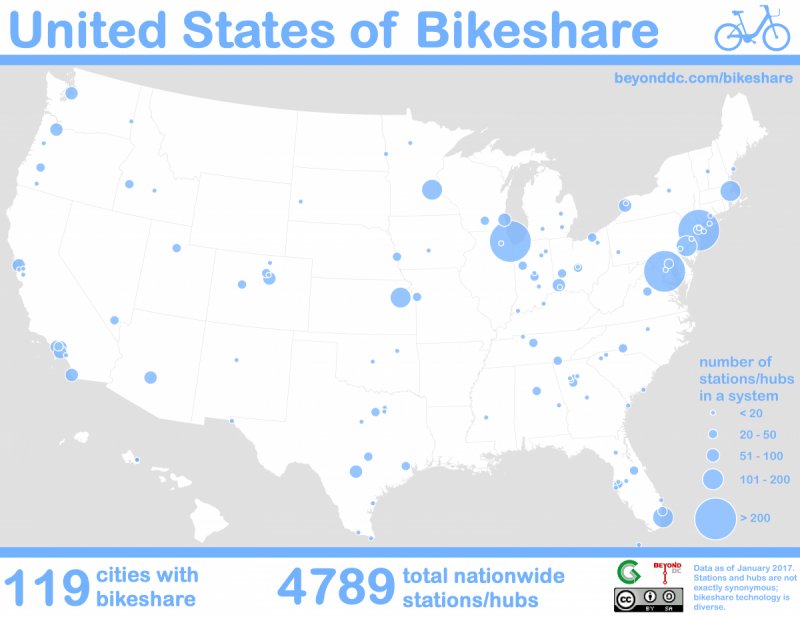
The largest networks by far are in New York, Chicago, and Washington. A second tier is led by Minneapolis, Boston, and Miami.
Of the 20 largest urban areas, only Saint Louis and Detroit still lack bikesharing. Unfortunately, Seattle's Pronto will be the first major US bikeshare system to fail when it shuts down in March, adding a third.
Read the rest of the story here.
Wednesday, February 8, 2017
The Cost Of Auto Orientation
In the United States we've proceeded for sixty years with reconfiguring our public spaces to accommodate the automobile. The built in assumption of this approach, especially when it comes to commercial property, is that the more cars driving by the better. What we've overlooked in our haste to "modernize" is the lower return on investment we get from this approach, even under ideal conditions. Today we need the humility to acknowledge that our ancestors -- who built in the traditional style -- may have known what they were doing after all.
Highway 210 runs east/west through downtown Brainerd. In the hierarchical road system, it is the top of the pyramid and would be classified in most places as a "major arterial". It is designed as a STROAD (a street/road hybrid), attempting to apply highway design standards to what otherwise would be an urban street. In doing so, it has dramatically transformed the land use pattern of the area.
The picture below highlights two blocks that front the highway corridor. The one on the left, which we've labeled "old and blighted", is a block that has retained its traditional development pattern. To the right we have identified the "shiny and new" area, the block that has recently been transformed to an auto-oriented development style, to the glee of city officials and local economic development advocates. In between is a hybrid of the two; part traditional and part auto-oriented.
Read the rest of the story here.
Tuesday, February 7, 2017
Telegraph Avenue Parking-Protected Bike Lanes Show Stunning Results
Less than a year after opening a dramatic redesign of Telegraph Avenue in downtown Oakland, the city is reporting huge benefits from the project. According to the new Oakland DOT’s short Progress Report: Telegraph Avenue Complete Streets [PDF], the new parking-protected bike lanes, while flawed, are already producing more-than-promising results.
For the first time in five years, says the report, there have been no pedestrian crosswalk collisions reported along the section of the street that was reconfigured. The total number of collisions along the corridor decreased by forty percent in 2016 compared to the average number of collisions between 2012 and 2015. The lanes opened in April last year.
Read the rest of the story here.
Monday, February 6, 2017
Support Of The Colorado Safety Stop Bill
Ridership in the United States is up across the board. Over the past 10 years choosing a bike for transportation has become less an alternative and a more regular choice for many. Yet across the United States, our infrastructure and culture of moving people from point A to B is still car dominate.
Recently, the Federal Highway Administration changed how they measure traffic from counting vehicles to counting individuals. Finally, we are focusing on moving people; options besides single occupancy vehicles are taking the main stage. Public transportation, biking, and walking effectively now matter more than ever before.
With this timely news from the FHWA, a Safety Stop bill was introduced earlier this month to the Colorado Senate. The Colorado Senate Bill 93 was introduced by Senator Andy Kerr to rethink the “Operation Of Bicycles Approaching Intersections.” This bill would change how cyclists handle intersections with stop signs or stop lights.
It is often referred to as the “Idaho Stop,” named after the state that first passed a similar law in 1982. To all the naysayers, the law works, and it has been shown in a University of California at Berkeley School of Public Health study that the year after the Idaho law passed there was a 14.5% reduction in cycling-related injuries in Idaho.
Read the rest of the story here.
Subscribe to:
Posts (Atom)