Thursday, June 30, 2016

Building Bike Infrastructure Is The New Economic Development

It didn’t feel right when I heard via the Washington Business Journal that Arlington County, Virginia paid energy company Opower $2M to remain and not move away (Opower to Remain In Arlington, February 8, 2016; Daniel J. Sernovitz). This goes against years of policy of not paying companies in money or tax breaks to stay or come to the County. Arlington had always refused to play the old economic development game of attracting and retaining companies by essentially bribing them. If a company didn’t recognize the jurisdiction’s bona fides of proximity to the capital, great schools, great transportation and a young and educated work force than were they a good fit anyway? With a growing vacancy rate perhaps times are changing.
But could the County have gone another way? Word on the street was Opower’s young Millennial staff was looking for, amongst other things, a more bike-friendly place and the vibrancy that brings to place making.
From Pittsburgh to Chicago, from Salt Lake to Austin, and places like San Francisco,Seattle, Portland, Indianapolis, the District and many more, leaders are increasingly fighting the economic development battle by building bike infrastructure which attracts Millenials, and the companies that want them.
Read the rest of the story here.

Wednesday, June 29, 2016

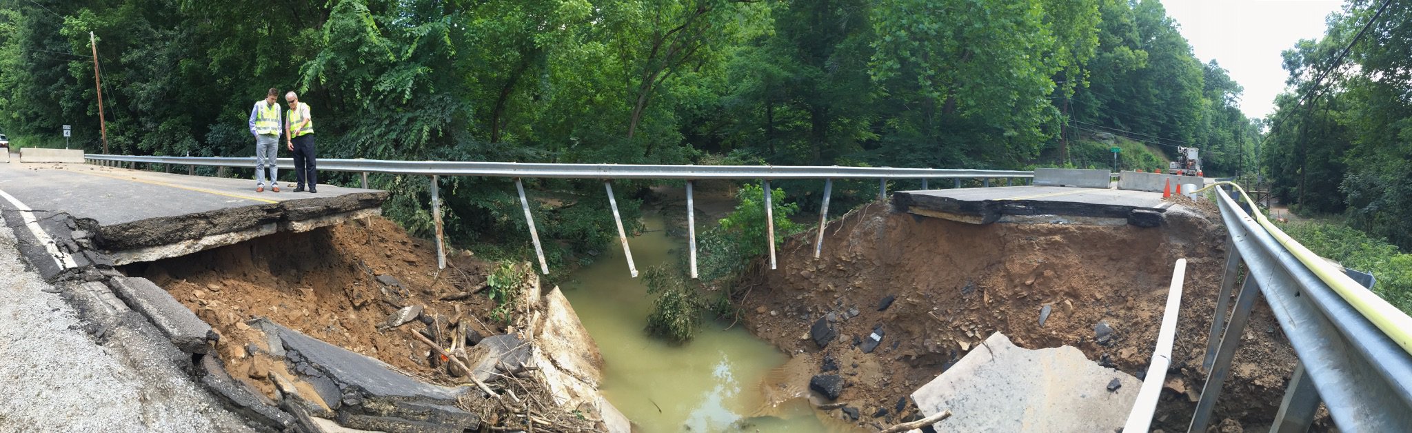
WVDOT Dealing With Flood Damage


Every Place Counts Design Challenge Allows Us to Design a Better Future

Today, I traveled to Philadelphia and met Mayor Kenney on the plaza of the Vine Street Expressway. For Philadelphians, this roadway represented almost 30 years of planning and was intended to expedite commuting between the Delaware and Schuylkill Rivers, ultimately decreasing half-hour trips to just a few minutes. However, that vision was never realized and three communities, including Chinatown and the Callowhill District bore the brunt of the damage as many homes, businesses, schools, places of worship, and other places of cultural and community significance were razed to make way for the expressway. Presently, the Vine City Expressway is a six-lane corridor not easily navigated on foot or in vehicle, and represents a very real, physical barrier for those that must traverse it daily.
Read the rest of the essay here.

Tuesday, June 28, 2016

Bike Lanes Nurture Growth Of Meals On Two (And Sometimes Three) Wheels

As more and more Canadian cities hop onto the protected bike lane bandwagon, new economic opportunities are being presented to merchants who chose to cater to customers arriving by foot or bicycle. While they may purchase less per visit, study after study has discovered that – over the course of an entire month – people arriving by those two modes of transportation regularly outspend drivers at locally owned businesses such as cafés, bars, restaurants, and convenience stores.
Here in Vancouver, forward-thinking entrepreneurs have taken full advantage of the growth in cycling, and strategically located their storefronts along the bustling bikeways. Case studies such as Bomber BrewingTandem Cafe, and Cycle City Toursdemonstrate that bike lanes really do mean business, and people on bicycles are far more likely to stop and make an impromptu purchase than those racing by in a car.
Let’s not also forget the fact that Downtown Vancouver Business Improvement Association President and CEO Charles Gauthier has become one of the most vocal proponents of bicycle infrastructure in the city, reversing his organization’s position on the protected bike lanes, supporting walking and cycling improvements to theBurrard Bridge, and championing the imminent arrival of bike share this summer.

Read the rest of the story here.

Monday, June 27, 2016

Route 460 Final Supplemental Environmental Impact Statement Ready For Review

RICHMOND – The United States Army Corps of Engineers (USACE) and the Federal Highway Administration (FHWA) have issued a Notice of Availability of the Final Supplemental Environmental Impact Statement (SEIS) for the Route 460 Project Southeast Virginia. Comments will be accepted for 30 days following the Notice of Availability, published on June 24, 2016.  After the close of the comment period and consideration of any comments received, a permit decision from USACE is anticipated.
Following the issuance of a Draft SEIS in September 2014, the Final SEIS is the next step in the environmental review process, under the National Environmental Policy Act (NEPA) of 1969, and provides decision-makers with information about the Project to help them decide whether or not to advance it. Comments received during the public comment period on the Draft SEIS have been considered and addressed in the Final SEIS. The Final SEIS provides a detailed description of the development and identification of the FHWA/VDOT Preferred Alternative, which was first presented during VDOT’s May 2015 public meetings.
If a favorable permit decision from USACE is received, the Project will also be scored under SMART SCALE: Funding the Right Transportation Projects in Virginia (formerly, Virginia House Bill 2). In addition, a Record of Decision on the Final SEIS must be received from FHWA. Once the necessary environmental decisions have been made and the Project is scored, the Commonwealth Transportation Board will decide whether or not to advance the Project.
The Final SEIS may be viewed at the following link: http://www.route460project.org/learn_more/seis_final_docs.asp. A printed version of the Final SEIS may be viewed during business hours at the following locations:

Public Libraries:
Isle of Wight
Windsor Branch - Blackwater Regional Library
18 Duke Street,
Windsor, VA 23487
757-242-3046
Sussex County
Wakefield Branch - Blackwater Regional Library
100 Wilson Avenue
Wakefield, VA 23888
757-899-6500
Southampton County
The Walter Cecil Rawls Library
22511 Main Street Courtland, VA 23837
757-653-2821
Surry County
Surry Branch - Blackwater Regional Library
270 Colonial Trail East
Surry, VA 23883
757-294-3949
Prince George County
Prince George County Library
6605 Courts Drive
Prince George, VA 23875
804-458-6329

VDOT Offices:
Hampton Roads District:
1700 North Main Street
Suffolk, VA 23434
757-925-2500
Petersburg Residency (Prince George)
4608 Boydton Plank Road
Petersburg, VA 23803
800-367-7623
Williamsburg Residency (Surry)
4451 Ironbound Road
Williamsburg, VA 23188
800-367-7623
Richmond District
2430 Pine Forest Drive
Colonial Heights, VA 23834
804-524-6000
Franklin Residency (Isle of Wight, Southampton, Sussex)
23116 Meherrin Road
Courtland, VA  23837
800-367-7623

Project Background: 
The overall purpose of the Route 460 improvements is to construct a facility that is consistent with the functional classification of the corridor, sufficiently address safety, mobility and evacuation needs, and adequately accommodate freight traffic along the Route 460 corridor. Support for such improvements is based on identified needs to address roadway deficiencies, improve safety, accommodate increasing freight traffic, reduce travel delay, provide adequate evacuation capability, improve strategic military connectivity, and support local economic development plans.
Online resources:
Route 460 Project Southeast Virginia Website: www.Route460Project.org

Saturday, June 25, 2016

Four Reasons To Bike In Arlington

Maybe you’ve heard that Arlington County is a good place to get out and explore on your bike, but something inside of you still isn’t sure. As a team of avid bikers and bike novices, we understand your concerns, so that’s why we wanted to share four amazing reasons why you should give biking a try in Arlington County.

Reason #1: The 2015 Bike Map

The BikeArlington bike map isn’t the best map of Arlington just because it says so on the cover! The hugely popular bike map is extremely detailed, with every Arlington street named, parks and community centers labeled, bike lanes and trails shown as well as the famous Arlington Loop, restrooms, drinking fountains, steep hills, bike shops, Capital Bikeshare stations and more. The map also features trail connections from Fairfax County and Washington DC, because although biking in Arlington is fun, who wants to be limited?
The back side is full of useful information, so be sure to turn it over and check out the bike tips. Whether you keep it for bike trip planning, figuring out where Gulf Branch Nature Center is, or wanting to find the closest Metro station to a Capital Bikeshare station, this map has you covered. Keep one where you work and at home, then you are always prepared in case of an emergency, too.

Read the rest of the reasons here.

Thursday, June 23, 2016

Columbus Proves Parklets Don’t Have To Be Perfect

In all of Columbus, Ohio, two short blocks and three parking spaces might sound small, but for nonprofit advocacy group Transit Columbus, they’re the seed from which a more pedestrian-friendly city might grow. The group, whose mission according to board member Jess Mathews is to champion a better-connected Columbus with a “21st-century transportation system,” just opened its fourth temporary pedestrian project this week. 

Two blocks of West Cherry Street have been closed to traffic, painted bright blue with big red and small yellow polka dots, and enhanced with picnic tables, planters, and a community mural. A few blocks away, Transit Columbus’s third parklet is installed in a parking space in front of Café Brioso, and just got approval from the city to remain two months longer than planned — until September — because it’s been so successful.

“Our organization fully understands the importance of improved public spaces, streets being not only for all modes of transportation but destinations as well,” says Mathews. While most of Transit Columbus’ work focuses on expanding public transportation options, the group’s Placemakes initiative is all about activating streets as public space. “Streets are a huge asset for every city that I think goes unrecognized or are not always fully used to their potential.”
That’s in part because a lot of people don’t see them as public space — even though many argue we should count them as such. “[People] think of public spaces and they think of parks or beaches, and not necessarily streets,” says Mathews. “So we try to broaden their minds on that.”
The West Cherry Project may be the first in Columbus to close off a street to create a pedestrian plaza. Technically, it’s temporary, a two-month public engagement process that kicked off last week. But Mathews says the city is already in talks about keeping the space longer, and possibly extending it. West Cherry Street is just four blocks of downtown Columbus, closed to through traffic on one end and feeding into a riverside park on the other. If it were permanently preserved as a pedestrian space, it could serve a vital role in connecting the Scioto River to the High Street commercial corridor.

Read the rest of the story here.